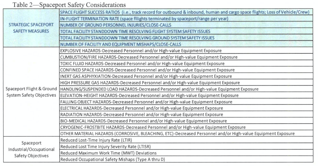
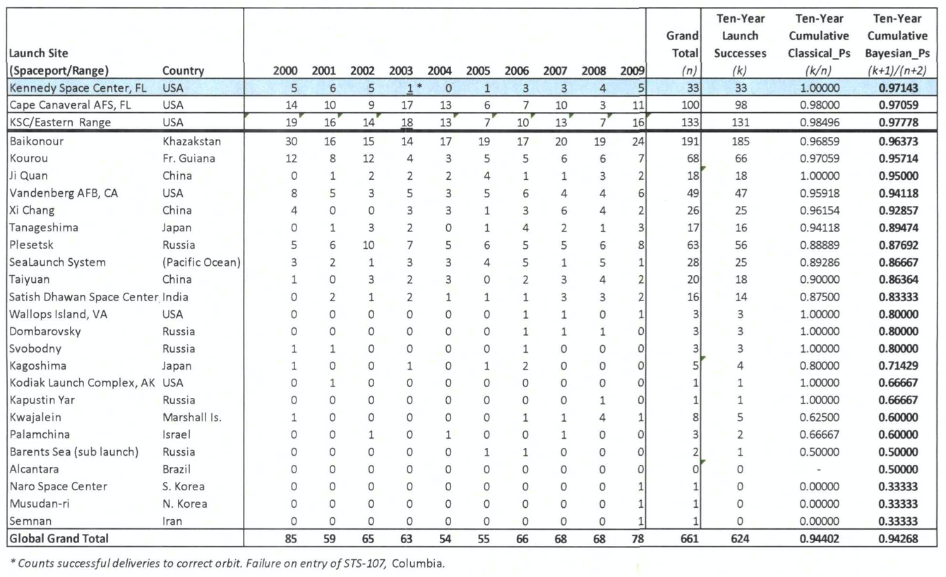
corridor
Rockets
When he began to dream about the Rocket with some frequency, it would sometimes not be a literal rocket at all, but a street he knew was in a certain district of the city, a street in a certain small area of the grid that held something he thought he needed. The coordinates were clear in his mind, but the street eluded him. Over the years, as the Rocket neared its fullness, about to go operational, the coordinates switched from the Cartesian x and y of the laboratory to the polar azimuth and range of the weapon as deployed: once he knelt on the lavatory floor of his old rooming house in Munich, understanding that if he faced exactly along a certain compass-bearing his prayer would be heard: he’d be safe. He wore a robe of gold and orange brocade. It was the only light in the room. Afterward he ventured out into the house, knowing people slept in all the rooms, but feeling a sense of desertion. He went to switch on a light—but in the act of throwing the switch he knew the room had really been lit to begin with, and he had just turned everything out, everything. . . .The A4 operational-at-last hadn’t crept up on him. Its coming true was no climax. That hadn’t ever been the point. “They’re using you to kill people,” Leni told him, as clearly as she could. “That’s their only job, and you’re helping them.” “We’ll all use it, someday, to leave the earth. To transcend.” She laughed. “Transcend,” from Polder? “Someday,” honestly trying, “they won’t have to kill. Borders won’t mean anything. We’ll have all outer space. . . .” “Oh you’re blind,” spitting it as she spat his blindness at him every day, that and “Kadavergehorsamkeit,” a beautiful word he can no longer imagine in any voice but hers. . . .” (Gravity’s Rainbow, Thomas Pynchon, page 579)
The UK should become the spaceport corridor of the Arctic-Africa Longitudes and develop its maritime future and Arctic vision alongside an Arctic (Polar) Orbital vision utilising next generation space technologies and applications. The UK could be an Arctic-African (Orbital) capital but in order to begin this process, it must frame its 21st C industrial strategy as one contiguous north-south developmental project, where the Belt is defined as the UK’s orbital/space domain and the Road, the UK’s maritime/manufacturing domain. To become a longitudinal corridor to growing African markets and remain a latitudinal switchboard / pivot region to continuing American / Asian / European capital markets will require reframing London as a key international spaceport centre offering financial, insurance, legal and engineering/exoplanetary expertise. The UK must embrace its northern powerhouse corridor with a bold northern sea/space powerhouse international strategy.
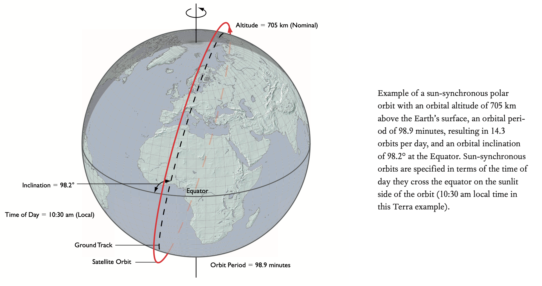
Sutherland Spaceport on Scotland’s coast is set to become the UK’s first spaceport, and is ideally positioned to allow rockets to place small satellites into north-south orbits that fly over Earth’s poles. Launch vehicles will fly to the north, taking routes over the Norwegian Sea between Iceland and Svalbard to ensure debris does not fall on populated areas. Such orbits are commonly used by Earth-observing satellites and low-latency communications stations including mega-constellations of commercial satellites. With further horizontal satellite launch facilities planned in Cornwall and Wales, the UK has an opportunity to lock-in the potential of a vast growth orbit corridor uniting a northern Arctic corridor maritime strategy with a Pacific Islands monitoring capability and West African economic partnerships.
Two events converged recently, I read Bruno Macaes’s short note on the United Kingdom as a Eurasian Capital, and followed the story on the Kiribati elections in which Kiribati’s pro-China president won a second term. I read a US-China Economic Commission Report in which a U.S. Diplomat stated ‘Pacific Island countries’ are not ‘small island countries. They are large ocean nations’ then noted the UK, a self-considered large ocean nation itself, has begun talks with the U.S., Australia, New Zealand and Japan to join the Trans-Pacific Partnership; for the past year has been pursuing a ‘Pacific Uplift’ strategy; will open three new High Commissions, in Samoa, Tonga and Vanuatu later this year doubling its diplomatic presence in the region; and has also doubled the FCO team in Fiji, with new roles on development, trade, oceans, regional organisations and programmes. I also discovered the news that British diplomat Richard Morris, due to take up position as British High Commissioner in Fiji in July had disappeared following a jog in Surrey not far from where I am writing.
Certainly there are moves to draw the UK into Eurasia, a possible London-Nur-Sultan-Singapore English common law legal golden triangle being one. Yet on focusing solely on the UK as a Eurasian Capital, what’s missed is how Eurasia itself is a shifting concept that is becoming distinguished as much by developments on its north-south axis as its east-west Mercatorian axis. Counter-intuitively, the same applies to the UK. Rather than frame the vision of being outside Europe as a move to re-capture far distant economies on the eastern-western plane, the UK should understand its position as being on the edge of the European Union’s orbit, as that of a manoeuvrable, polar orbital satellite able to utilise the full extension of an arc northward through the Polar Maritime Corridor to the Pacific and southward along a digital/space/ocean corridor to Western Europe and West Africa. This developmental UK Belt (space) and Road (maritime) corridor is counter-intuitive because it runs against the grain of imagery we are supplied with in which the world economy is shifting eastward and that to get the pie chase the sun as it rises. The reality however is that Eurasia is being pulled southward before it is pulled westward (see map below). The UK should understand that the corridor to unlock potential growth lies southward in a region between West Africa and East Africa arcing across the Indian Ocean to India, Indonesia and onward to Oceania, Australia and the Pacific Uplift Strategy, while at the same time from the UK’s northward azimuth, the Western Pacific opens up via the maritime/space corridors of the Arctic.
The Commonwealth should be reframed the Commonstealth for the speed and subtlety of this pivot toward a N-S spaceport corridor for the 21st Century. Of course the reality for the UK more fundamentally is that its power projection on the horizontal maritime plane cannot compete with the spend of the U.S. / China / India. The British Military is stuck in old naval models of projection that have been replaced by swarm, drone/amphibious and distributed/littoral operation concepts. The spaceport corridor idea is a multi-decadal plan, and must re-set the contours of how the UK undertakes diplomacy and partnership abroad as a mirror of diplomacy and partnership domestically. A corridor stretching north-south across the UK from proposed spaceports in Cornwall-Scotland should be developed as a serious idea in rebalancing the north-south, coastal-city divide. Why could the UK’s coastal port-cities not be reinvested in toward a state of the art space-manufacturing corridor. London’s financial, legal, tech, insurance expertise should be utilised to attract the best international talent from the Spaceport Corridor economies. What the UK needs is the parallax vision that a spaceport launch dares to dream, a nice quote describes how Britport 2049 might unify a green new deal with a broader progressive vision toward racial and gender equality, educational opportunity, north-south rebalancing:
“The deadlock of “resistance” brings us back to the topic of parallax: all is needed is a slight shift in our perspective, and all the activity of “resistance,” of bombarding those in power with impossible “subversive” (ecological, feminist, antiracist, anti- globalist . . .) demands, looks like an internal process of feeding the machine of power, providing the material to keep it in motion.The logic of this shift should be universalized: the split between the public Law and its obscene superego supplement confronts us with the very core of the politico-ideological parallax: the public Law and its superego supplement are not two different parts of the legal edifice, they are one and the same “content”—with a slight shift in perspective, the dignified and impersonal Law looks like an obscene machine of jouissance. Another slight shift, and the legal regu- lations prescribing our duties and guaranteeing our rights look like the expression of a ruthless power whose message to us, its subjects, is: “I can do whatever I want with you!” Kafka, of course, was the inimitable master of this parallax shift with regard to the edifice of legal power: “Kafka” is not so much a unique style of writing as a weird innocent new gaze upon the edifice of the Law which practices a parallax shift of perceiving a gigantic machinery of obscene jouissance in what previously looked like a dignified edifice of the legal Order.
The UK must focus its Belt (space) and (Road) Dream on diplomacy and partnership that is carefully calibrated to capabilities of UK Spaceport PLC expertise in next generation technologies and institution building. At the same time, the Commonstealth global project should be framed around the subtlety of constellation technologies (whether drones, satellites, microchips, driverless cars, nano-robotics, quantum AI – small is beautiful. The UK as a small island big ocean nation (SIBON) should champion these technologies and an expertise in their application to countries that are of similar size and coastal potential. The UK is also a world-leader in television, music and media that needs a geometry to get behind – the Spaceport Corridor is one and just as China is opening up Eurasia to imagination through landbridges from Europe to the Pacific, the UK should open out a conceptual Belt and Road across its Arctic-African orbital dimension.
The UK-Africa Space Belt
The UK should become a key hub in a spaceport corridor arcing the Prime Greenwich Meridian, and driving its longitudinal potential into the lateral Indo-Pacific Concept that China is developing in the Belt and Road and that the U.S., India, Australia, Japan, Indonesia are competing to label a Free and Open Indo-Pacific among other national variants. London as the capital of a big ocean nation should develop its synchronising finesse as a switchboard and flow-point in moving dollars to and from American, European, Asian and African space markets and should continue to develop its longitudinal / time zone advantages into a first mover position in a Southern Atlantic – Indo-Pacific bi-ocean concept linking South American, West African and East African economies into a larger Indian Ocean/Pacific Ocean latitudinal belt. Energising this orbital corridor of the Atlantic into the Eurasian/Asian meridian lines should be built around a strong multilateral component. The UK cannot compete with China and the U.S. on investment in this emerging arc and so should position itself as a Small Island, Big Ocean Nation (SIBON) specialising in small satellite agri-tech, polar orbital launch provisions, space law and arbitration, space insurance and financing. The UK Export Finance programme should be expanded to a UK-Africa Spaceport Finance Programme and should explore with the U.S. and European Union new multilateral institutions to embed the Sustainable Development Goals in new transcontinental structures and concepts of space development.
Africa is fast becoming a space continent, in a 2019 report, the space industry was expected to exceed U.S. 10billion by 2024. By 2050, the continent is also expected to account for one in four of the world’s consumers. Nigeria is at the fore of space sector developments and both UK and Chinese companies have been involved in its satellite programme. The first Nigerian satellite, launched into orbit in 2007, was built by UK based Surrey Space Technology Limited (SSTL ltd). At the same time, the China Great Wall Industry Corporation was contracted for the manufacture and in-orbit delivery of a communications satellite known as NigComSat-1. In January UK’s OneWeb was awarded satellite communication landing rights in Nigeria. In January, the UK government held the UK-Africa Investment Summit where Boris Johnson announced £620 million of investment in Africa and signalled African partners as a key target after Brexit. A quick search of UK / West African partnerships and in January 2019, DFID held the UK-West Africa Agritech Summit in Lagos, this month UK Export Finance lent £100m to build a 114-mile road in Benin, ‘The Benin project, the first of its type in the Francophone west African country to attract UK government financial support, will restore the major road between the cities of Bohicon and Parakou in the centre of the country with the aim of improving links with landlocked Niger. The deal follows UKEF financing of other projects, including a £110m upgrade of hospital facilities in Ghana and £244m to design, construct and operate 108 rural health clinics and hospitals in Zambia.’ Paul Collier’s The Bottom Billion explores in depth the constraints of countries that are landlocked, UKEF should seek to unify road development with a dual Belt development / vertical space component with West African partners.
This month, the UK also stepped up peacekeeping support in Mali and Senegal. The idea of a spaceport corridor must, and this is significant, as the dynamics are complex, fully consider how space technologies and space-enabled development policies might combat extremism and a growing presence of militancy and terrorism in the Sahel region by further supporting agri-tech, education and broader satellite-supported industries. The UK should establish how a spaceport corridor might also prepare and respond to pandemic threats, in May, NASA along with the European Space Agency (ESA), the Japan Aerospace Exploration Agency (JAXA), the Canadian Space Agency (CSA), and the National Centre for Space Studies (CNES), invited coders, entrepreneurs, scientists, designers, storytellers, makers, builders, artists, and technologists to participate in an all-virtual, global hackathon. During a period of 48 hours, more than 15,000 participants from 150 countries created more than 2,000 virtual teams exploring how space-based systems might learn about the spread, respond to and assess the impact and recovery paths after COVID-19, in Africa and the Middle East, numerous projects were implemented (https://covid19.spaceappschallenge.org/locations/africa-and-middle-east/). The UK should look to lead on developing new multilateral institutions that drive at agile development, youth collaboration and space science and humanities across a broad conceptual arc in the time-zone longitude of Africa-Europe, the emergence of Zoom video conference calls could furthermore drive collaborations between the UK government, education institutes, private space actors and African educational institutes and space-start up ecosystems.
In recent years, the UK Space Agency’s International Partnership Programme has undertaken projects broadly supporting Sustainable Development Goals – with the combining of the Department for International Development into the Foreign and Commonwealth Office, the IPP Programme should not be scrapped but further energised as part of a comprehensive meridian space corridor strategy: Project on deforestation prevention in Ivory Coast through Vivid Economics; Project on Forests 2020 in Ghana, and Kenya, through Ecometrica; Project on Advanced Coffee Crop Optimisation for Rural Development (ACCORD) in Kenya and Rwanda through Earth-i; Project on Pest Risk Information SErvice (PRISE) in Ghana, Kenya, and Zambia through CAB International; Project on Drought and Flood Mitigation Service (DFMS) in Uganda through Rheatech; Project on Flood and Drought Resilience in Ethiopia and Kenya through Airbus Defence and Space; FireSat project in Kenya, Namibia, and South Africa through ClydeSpace; Project on Modelling Exposure Through Earth Observation Routines (METEOR) in Tanzania through the British Geological Survey; Project on Satellite Enablement for Disaster Risk Reduction in Kenya (SatDRR Kenya) through Avanti Communications; Project on Coastal Risk Information Service (C-RISE) in Madagascar, Mozambique and South Africa through
Satellite Oceanographic Consultants (SatOC); Project on South Africa Safety Initiative for Small vessels’ Operational Takeup (OASIS-TU) in Madagascar, and South Africa through exactEarth; Project on iKnowledge in Tanzania through Avanti Communications; Project on SatCom for Nigerian Health Services through Inmarsat; Project on Property database for Dakar City in Senegal through Airbus Defence and Space; Project on Renewable Energy Space Analytics Tool (RE-SAT) in Seychelles, and Mauritius through Institute for Environmental Analytics (IEA)
In Space in Africa’s 2019 Annual Report, from 1998 through May 2019, 32 satellites were launched into orbit by eight African countries: Algeria, Angola, Egypt, Ghana, Kenya, Morocco, Nigeria, and South Africa. In addition to the 32 national satellites, African institutions jointly funded three other satellite projects – RASCOM-QAF1, RASCOM-QAF1R, and New Dawn – for regional operations. 15 out of the 35 satellites were launched in the last four years, indicating the skyward growth rate at which Africa is embracing space technologies to power the continent’s growth and improve the lives of its people. The diverse satellite programmes include 14 Earth observation satellites, 10 communications satellites, 8 technology demonstration satellites, a satellite for scientiic experiments, an educational project satellite, and a military radar satellite. In a May 2020 U.S. – China Economic and Security Review Commission Hearing on China’s Strategic Aims in Africa, Joshua Mersevey noted how China’s approach to Africa is fully integrated across military, diplomatic and economic activities. China may already have a military base on Africa’s Atlantic coast and Namibia’s coastal town of Swakopmund hosts a Chinese satellite tracking station as part of its civilian space program. Paul Nantulya noted In the past six months, China delivered tanks to Nigeria, helped Ethiopia and Sudan launch satellites, exercised with the Tanzanian and South African militaries, attended a pass out ceremony of junior officers trained by the PLA at Zimbabwe Staff College, inaugurated a mid-year’s new command in staff college, launched Africa’s first integrated pubic security center in Angola, and dispatched General Xu Qiliang to Southern Africa. He is second in military authority only to Xi Jinping […] In addition, as part of the Access to Satellite TV for 10,000 African Villages project, Chinese media company StarTimes broadcasts Chinese television and news to rural Africa.
The Three Laws of Meridian Multipolarity
The UK cannot compete with the U.S. and China in Africa in investment, which is why the UK should develop the idea of a spaceport corridor alongside a firm recognition that multipolarity also pertains to lines of longitude. In seeking to astrophysicalise a new language of partnership the UK should seek to define the three laws of meridian multipolarity derived from the behaviour of equatorial satellites in geosynchronous orbit, these are:
- First Law of Meridian Multipolarity: Every Country has potential in Longitude
- Second Law of Meridian Multipolarity: Thrusters must continuously correct for Longitudinal Drift
- Third Law of Meridian Multipolarity: Thrusters cause loss in communications
To stay the course governments must utilise thruster policies to sustain the optimal conversion of potential energy in its longitudinal belt. The UK should ensure the energy of the new DFID/FCO merger is constantly monitored and corrected for longitudinal drift in policy direction or focus. A critical issue in geosynchronous satellite stationkeeping and momentum management is managing excess angular momentum from earth spin and solar radiation pressure and cancelling inclination drift caused by solar and lunar gravity. Out-of-plane thruster firings are used to correct satellites from the effects of longitudinal drift but this often leads to imaging disruption due to attitude transients and loss of orbit knowledge.
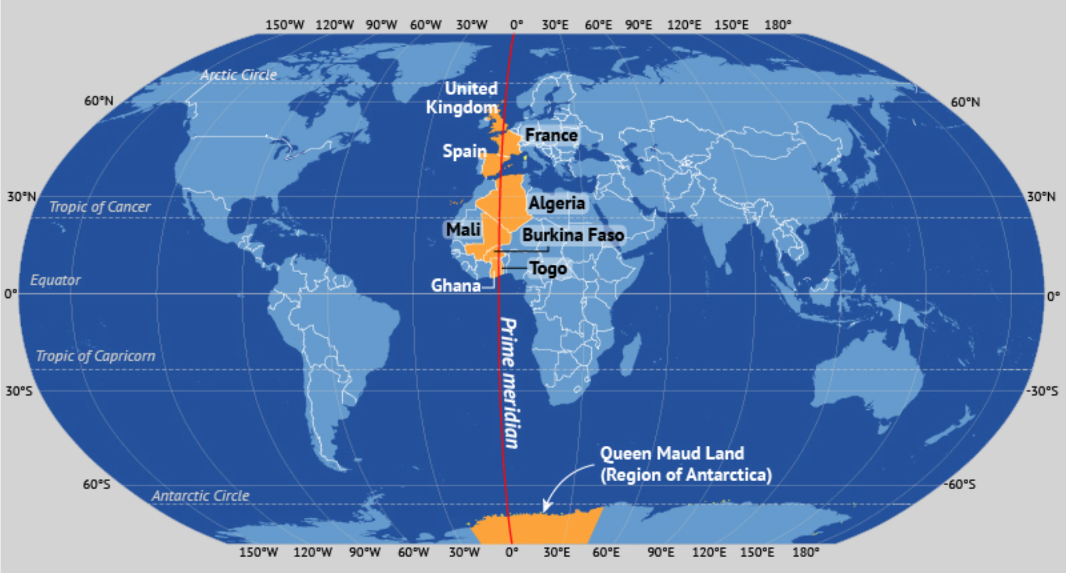
The UK has and should seek to understand its civil service as a satellite that can experience longitudinal drift creating communication and image transmission errors. In furthermore stating that the UK should seek to develop a spaceport corridor along its prime meridian, the conversation should explore how longitude itself is a concept with historical routes in colonialism, in Mason & Dixon (see Appendix), the novel by Thomas Pynchon, he explores how the Mason-Dixon Line, a demarcation line between four U.S. was surveyed between 1763 and 1767 by Charles Mason and Jeremiah Dixon in the resolution of a border dispute involving Maryland, Pennsylvania, and Delaware in Colonial America. It later became informally known as the border between the free (Northern) states and the slave (Southern) states, a quote from the book: “They came from the Sky, they prepar’d to emplace these Webs of right lines upon the Earth, then without explanation they went away again. Their work is being continued by the Jesuits, inscribers of Meridians, whether in blind obedience to some ancient Coercion, long expir’d, or in witting Complicity with it, who can say?” Hence the significance in defining the three laws of meridian multipolarity, that is to say that the spaceport corridor of a prime meridian variant is one such possibilization arc that the UK might explore in partnership with the governments and people of France, Spain, Algeria, Mali, Burkina Faso, Togo, Ghana – every country along this arc is also however distinguished by its multiple possible meridian possibilization arcs. In opening out the possibilization of longitude in a world dominated by an image of latitude and world economy shifting eastward, it might also be utilised to ask interesting questions along the arc of a polar orbit, opening up new conceptual horizons. A Unit should be created in the Civil Service to track the possibilization arc between meridian lines throughout the world and their potential to arc into latitudinal megaconcepts such as the Indo-Pacific, Eurasian landbridge, Belt and Road and so forth. In a 2010 Report of the UK Space industry, the authors explored a possible 2030 scenario of a UK polar-orbit constellation, the sheer depth of connections this satellite makes in a single day indicates the depth of potential for space-based meridian partnerships.
“Following the launch of four surveillance satellites by the UK’s imagery service provision organisation in 2013 the constellation has grown with contributions from partner nations to provide near real-time imagery via the commercially run data relay network based in London. Data from all of the satellites is collected and supplied to the UK Executive Space Agency, the ‘anchor tenant’ for the constellation, and a variety of commercial customers as well as to partners. The satellites operate in near-polar orbits, providing real-time access to any location on the globe at least once per day. This extremely timely imagery capability gives the UK-led constellation a significant commercial edge and the UK’s anchor tenancy has enabled three UK- based former SMEs to become global names in image-based services. The satellites are equipped with multiple sensors that enable different resolution images to be captured, allowing a wide range of government departments’ agendas to be addressed.
1.00am – Following a major earthquake In New Zealand, the agile satellites are used to collect high-resolution imagery of lines of communication and determine which routes are open for the provision of aid. Data is supplied to FCO and DFID. 2.30am – Areas of the Indonesian rainforest are imaged and data collected to provide confirmation that areas of vegetation that have been set aside under an international climate change treaty are indeed unaffected by illegal logging. Data is supplied to DECC. 4.00am – Areas of China are collected at high resolution to support a national mapping programme. Data is supplied to a commercial imagery customer in Beijing. 5.30am – Areas of Bangladesh are mapped as part of a DFID-sponsored programme to plan for, and hence mitigate, the damage and displacement caused by flooding and a global rise in sea levels. 7.00am – During passes over the latest war zone the satellites receive commands, and wide-area images are collected over current operational areas. These are compared with imagery collected over previous days and weeks to indicate areas of recent change, and used to cue persistent unmanned aerial system (UAS) coverage, saving many hours flying time. The satellite data is supplied via a direct in-theatre downlink to the allied theatre commander. The entire operation is completed within 20 minutes. One of the satellites is also used to survey a building thought to be involved in the manufacture of Improvised Explosive Devices. 8.30am – Over the east coast of Africa, the satellites gather imagery which is down-linked directly to the international naval task force addressing piracy in the region. Data is supplied to MOD, the FCO, and the UK’s Allies in the region. During the pass, water levels behind dams on important water courses are monitored using high-resolution data to assess the likelihood of tension over access to this key resource. Data is supplied to FCO and MOD for conflict prevention. 11.30am – A similar imaging pass is conducted off the Western coast of Iberia on behalf of our European allies. Maritime data is exchanged under an MOU agreement which provides the UK with access to Space surveillance data from European satellite systems such as Helios, SAR- Lupe, and COSMO-SkyMed. The surveillance data is used to monitor the potential positions of boats off North-West Africa being used by illegal immigrants attempting to enter the EU, (thus benefiting the Home Office).
10.00am – In southern Africa, DFID targets are monitored to evaluate the adoption of improved agricultural methods promoted under a UK- sponsored education programme. Parts of central Africa are monitored to assess the likely grain harvest, the failure of which would lead to a humanitarian crisis. Again, data is supplied to DFID. 1.00pm – The satellites are used in wide-area mode over the area south of Greenland to collect data for maritime safety on sea surface conditions, weather patterns, and icebergs. Data is supplied to a variety of maritime agencies on a commercial basis. 2.30pm – Maritime data is again collected, this time over the Caribbean, and is supplied via direct downlink to the RN vessel conducting drug interdiction duties in the region. Data is supplied to MOD and combined with Automatic Identification System information to highlight illegal vessels. 4.00pm – The constellation is cued to map the path of destruction caused by a major tornado over the central states of the US on the previous day. The data is sold to a commercial news organisation, which includes it in their evening news bulletin. 5.30pm – The forest fire season is close to its peak, and areas of Los Angeles are at risk. Imagery is acquired of the smoke plumes to aid the efforts of the fire-fighters and supplied to the UK’s principal ally on humanitarian grounds. This process is coordinated via the International Charter, which is invoked on the UK’s behalf by the Cabinet Office. 7.00pm – Arctic images are collected for the oil and gas industry, which is monitoring movements of the ice sheets to maximise exploratory drilling opportunities in the seas off Northern Alaska. Data is supplied on a commercial basis. 8.30pm – Imagery of the North Pacific is collected to help marine pollution clear-up operations in the region. The motion of the ocean currents, which constrain the debris, is mapped, and these are used to direct the clean- up operations. Imagery is supplied to an international consortium. 10.00pm – Satellites are used to collect wide- area imagery of Antarctica to provide an update on the maximum winter extent of the Southern Hemisphere ice sheets to evaluate the potential effects of global warming. Data is supplied to DECC. 11.30pm – UK coverage is used for multiple purposes, including support of 3D digital mapping to generate hi-res maps for the Home Office and DEFRA to monitor changes in land use. Images are also used to assist fisheries protection patrols by providing ship-detection data to DEFRA to help target suspected illegal fishing activities off the East coast of Scotland.”
Spaceport London
From Lloyds of London space insurance, to space law magic circle expertise, to industry robotic and nuclear fission engine innovation in Oxford, exoplanetary breakthroughs in Cambridge, small satellite and rocketry startups in Glasgow, regularized spaceport launches in Scotland and Cornwall, the UK could become the spaceport capital between Asia, North America, Europe and Africa. However, there is also competition in this space, Norway is kickstarting launch capabilities at Andoya, as is Sweden, Russia at Plestetsk and Kasputin Yar. Where the UK might lead is in offering a full package across space manufacturing, financing, insuring, launching and monitoring capabilities in a corridor between Cornwall (southwest) – London-Oxford-Cambridge (southeast) – Edinburgh/Glasgow/Sutherland (north). A British Northern Powerhouse Strategy should realign to a Northern-Southern Space Powerhouse Strategy linking Sutherland Spaceport in the Scottish Highlands with Cornish spaceports, both connected to a network of Bruno Macaes’s charter city-port clusters building the next generation of in situ resource utilisation technologies, 3D printers, remote sensors, micro-satellite, micro-chips, robots. Every exoplanetary research discovery should be published on stock-market ticker tape in the House of Commons and the House of Lords, Parliament should be brought into the 21st Century, and fully NASAfied.
More significantly the United Kingdom as a first mover in the longitudinal spaceport corridor could re-energise the UK’s maritime possibilities. Outer space, and space-enabled capabilities of navigation, sensing, information collection and coordination (only imagine how COVID-19 might have been solved through space enabled analytics, the next pandemic response should be space-led) could in the immediate be utilised to build Glaswegian satellite expertise into a constellation of space-manufacturing and port facilities in Scotland and the north of England. As the Arctic northern passage opens up, the UK as a spaceport corridor connecting West Africa to Western Europe and the UK should look to build alliances in its northern neighbourhood with Norway, Sweden and serve as a conduit between diplomatic frictions of the European bloc, the U.S. and Russia. Along the Prime Meridian, the UK should build a strong network of spaceport expertise and alliances throughout Africa, not only in ongoing telescope and exoplanetary / astrophysical observation but in a broad space science fiction cross-educational programme, the constant perspective should be from space, how can we solve this problem from space, how can we draw these policy areas together from space, the fourth industrial revolution in industry, manufacturing and development should be resolutely space-led and informed by space analytic capabilities.
Project Reset, Project Restart will exhibit a high sensitivity to initial conditions and so the UK must quickly re-set the mental map with which its understands its global position and possibilities in the 21st century world. This 2019 paper by Vidvuds Beldavs (https://www.thespacereview.com/article/3811/1) on Modern Monetary Theory and Lunar Development makes the case that MMT can be used to create as much money as needed to fund a long-term lunar development plan, much as an MMT type of scheme, quantitative easing, has been used by the US Federal Reserve to inject upwards of $10 trillion dollars in the US economy following the economic crisis of 2008 to enable sustained economic recovery marked by low inflation and strong job growth. The same might be applied to a post-Brexit, post-COVID-19 pre-22nd Century vision as the UK as a spaceport corridor to the world
For a global United Kingdom to understand its place in the world, all directions are possible, god is dead, bring forth the 360 degree auroral/ocean scanning. Which is where London between ethanolia and high-skills is a world-leader. Watch the video above of London in a turning webcam, scanning, analysing the rainlight fallen out of the northsea, time-syncing Asia and America at Canary Wharf. Scanning like this should re-dimensionalise itself to hold the north-south axis (Africa / the Arctic ) as significant as the east-west axis between Europe and Asia to B future. On the outside of Europe, the UK can furthermore act nimbly and fast with state aid and foreign trade partnership negotiations to develop the north-south axis where Europe is caught in internal battles over its poorer periphery southern states and core Franco-German dyad, and the perennial threat of Russian encroachment and NATO-retrenchment. The UK of the new space age must also think clearly about how to sync and return its vertical analytic capabilities – eyes looking deep into legal matters, eyes looking into test tubes, eyes looking into microchips and satellites and north sea oil pipes and high-end technologies – to a more horizontal, maritime, macro-possibilising, rephysicalised concept of production. The UK in this regard is not a small island on the periphery of Europe but a large ocean nation, it is not a services economy, but a services+fourth industrial high-end engineering space assets society. For too long I think we have vacated the sense of geometry, of distance and horizontal depth and opportunity for a concept of evolution within a United States of Europe at the direction of an invisible hand in Brussels with concepts of constant flow, liberalisation, integration, leading a globalist stream of thought that has forgotten the power of state-led maneuver. The U.S. and China meanwhile strongly maintained their sense of geometry.
Liberalisation, integration, such concepts should not of course be lost but held again at a cognitive dissonance with a concept of geometry, of shape, of stock, of ports, with the UK returning, near-shoring the idea of itself once again as a maritime nation at the door of the the five defining oceans of the 21st Century (Atlantic, Arctic, Indian, Pacific, Outer Space) which might be unlocked through a miniaturised British meridian Belt and Road development programme of its own. In the 21st Century the engine of future growth will be outer space and how it threads all economic activity together – financial, industrial, agricultural, social. The UK should establish itself as a first mover on this new age outside Europe and all of the endless talk of the death of the liberal project, the European enlightenment yada yada, this for one is merely a lack of perspective / understanding / energy toward the opportunities opening up in regions other than the Middle East, in Africa, in the Indo-Pacific, knitted through space. Russia will perenially exploit perceived weaknesses on the eastern edges of Europe, more so now that the U.S. administration has re-deployed U.S. troops from Germany to the Indo-Pacific region, which draws the optics of European leaders constantly east and back to Mercator’s map – the UK should take advantage of exploring the north-south axis as this happens.
Polar Orbital Space Race
Sutherland spaceport should be prioritised in Whitehall. Sutherland, located within the Melness Crofting Estate, on the A’ Mhòine peninsula in Sutherland, Caithness and Sutherland, Highland, Scotland, United Kingdom, is ideally placed for launching small satellites to polar orbit and Sun-synchronous orbit. Every Spaceport is associated with corresponding drop zones, or regions where rocket stages fall back to the Earth’s surface during a successful launch and where aborted missions are likely to crash land. The list of potential launch sites shrinks rapidly when considering the need for polar launch capabilities—launching directly into an orbit that passes over both the north and south poles—which requires drop zones to the north or south. The drop zone north of the proposed Sutherland Spaceport places Sutherland in an ideal band to launch polar orbital satellite constellations. It goes deeper than this. Such aerospace thought on ideal bands, azimuth ranges, flight paths should become a feature of the UK’s plans. Follow the orbit of one of these satellites for instance, and we might approach a broader conceptual Belt and Road dream for the UK.
Polar Orbital Capabilities are being explored by numerous other government/private collaborations. Whitehall must act quickly on Sutherland Spaceport and combine this with a long-term strategy to lock-in growth in the upcoming decades. To do so will require a bold rethinking of the British economy as a space economy that benefits all four nations of the Union. Utilising Modern Monetary Theory rather than an Austerity programme could kickstart the Spaceport Corridor Dream. We need to dream, Xi Jinping has outlined the China Dream; Elon Musk the American Space Dream; a UK dream needs to kickstart itself and not in the language of empire but the language of space. On June 04 2020, The Herald Scotland reported – Scottish spaceport dream could evaporate if pandemic delays planning approval, partner warns” Orbex, the Forres-headquartered aerospace company, is due to launch its Prime rocket from the proposed £17.3 million facility, but says other countries are moving faster than Scotland. “Norway, for example, has committed money to its spaceport and is moving ahead,” said Orbex chief executive Chris Larmour. Sutherland is a key entry point into a potentially huge growth corridor. I have outlined below potential Polar Orbit Competitors, in particular Portugal’s Azores facility which lies on the Meridian concept for a UK Longitudinal Space/Ocean Belt and Road.
This is a sweeping vision, I fully appreciate light on detail. In the polar orbital space, there are multiple spaceports that either already or plan to provide polar launch capabilities that could erode the UK’s position before it is even out of the gates. Which is why the UK government should think about not only ‘further supporting the UK space industry’, ‘further pledging funds to STEM tertiary education’ and so on, but wholesale transform the UK economy into a space economy. A quick search of the word ‘polar’ in CSIS’s March 2019 Spaceports of the World report notes the Portuguese, Swedish, Norwegian and American plans to construct polar orbital spaceport launch facilities.
Portugal – “In 2018, the Portuguese government announced its plans to build a spaceport on Santa Maria Island in the Azores archipelago.287 The Azores, an autonomous region of Portugal, is located approximately approximately 1,400 km (870 miles) off the Portuguese coast in the Atlantic Ocean. The project—called the Atlantic International Satellite Launch Programme—accepted proposals from commercial space companies interested in developing vehicles to launch from Santa Maria Island.288 Of the 14 companies that expressed interest—including 11 from Europe, two from both the United States and Roscosmos, the Russian space agency—the Programme has selected five companies to develop more detailed proposals for the spaceport.289 ArianeGroup, the European company that devel- oped the Ariane 5 rocket that launches from the Guiana Space Centre, is interested in managing the new spaceport on Santa Maria. The Portuguese government also plans to start commercial space launch from the island in 2021. While this represents competition Now postponed to 2021, Norway was due to host the Spaceport Norway (https://spaceport-norway.com/a-brief-history/). The creators of the programme plan to offer affordable services to those who are going to launch satellites weighing up to 500kg into polar orbits, or those, synchronized with the Sun at an altitude ranging from 400 to 1,000km above Earth.This project is a joint initiative of the Portuguese government and the regional authorities of the Azores, being carried out with technical support from the European Space Agency, which Portugal is a member of.
Norway – Andøya Spaceport was established as a project in 2018, with the aim of establishing the first European launch base for small satellites. It is mainly satellites for Earth observation and communications that are planned to be launched from Andøya, in polar- or sun-synchronous orbit. In polar orbit, the satellite passes above or near the Earth’s poles at each orbit. This is favorable for Norway as they then provide good satellite coverage of Norwegian areas, good communication and sea monitoring in the north. Sun-synchronous orbit means that the satellite passes a given latitude to two fixed local times, one for northbound and one for southbound passage. The satellite’s orbital plane rotates eastwards approx. 1 degree per day, and so it maintains the angle with respect to the sunlight and gets most light for its solar cells. In this way, satellites for Earth observation receive data with an equal amount of sunlight and can thus use data to analyze changes that occur on the surface throughout the year. (https://spaceport-norway.com)
Sweden – Spaceport Sweden is a company that plans to make Kiruna the primary European Spaceport for personal suborbital spaceflight for space tourism, research, education, and a hub for cross-industry innovation. The Esrange Space Center is a sub-orbital launch facility near Kiruna, Sweden. First founded by the European Space Research Organisation in the early 1960s, Esrange has been used to launch sounding rockets and high-altitude balloons dedicated to atmospheric science research. In 2017, the Swedish government funded a study to determine the feasibility of supporting orbital launches at Esrange. The following year, researchers concluded that the site could indeed be used to launch low-Earth orbiting satellites, most efficiently to polar orbits. Although no launch dates have been announced, a satellite launched from the Esrange Space Centre could potentially be the first object placed into orbit from mainland Europe. Nearby, at the Kiruna Airport, a company called Spaceport Swe- den hosts aircraft flights for tour- ists wishing to experience the sensations of low gravity and see the northern lights.254 In 2007, the Swedish government signed an agreement with Virgin Galactic, committing to building a regu- latory environment such that Spaceport Sweden or perhaps the Esrange Space Center could become the company’s first Euro- pean launch facility.
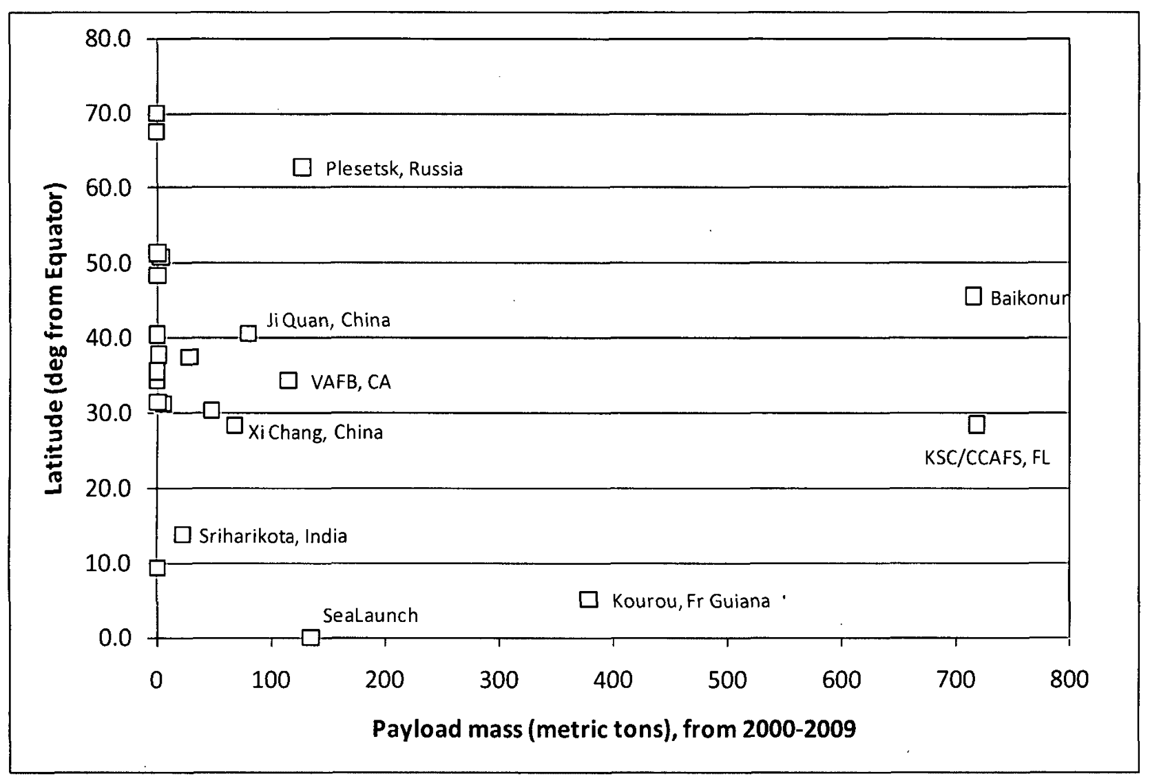
U.S.A. [Vandenburg] In 2018, the commander of the 45th Space Wing announced a new opportunity to launch southward from Cape Canaveral by first flying eastward and then turning south, following what has been called the “polar corridor.”68 This flight path from Cape Canaveral would require more fuel than launching directly southward into a high-inclination orbit—an option available at the spaceports at Vandenberg Air Force Base and the Pacific Spaceport Complex in Alaska—and has yet to be pursued by any launch provider out of the Cape. The vast majority of the Iridium and Iridium NEXT satellites—which make up a polar orbit network of commu- nication satellites—were launched from Vandenberg. Vandenberg’s location in the southwestern corner of the United States severely limits the orbital des- tination of space launches. While VAFB has launched more polar-orbiting satellites than any other spaceport in the world, orbital destinations with lower inclinations, closer to the spaceport’s 34.6° lat- itude, require orbital maneuvers after launch.
Russia – Yasny Launch Base—located on the Dombarovsky Air Base—is a Russian spaceport in the southern Orenburg Oblast, about 40 km (25 miles) north of the country’s border with Kazakhstan. The space- port was upgraded in the 2000s to support launches using the Dnepr launch vehicle.129 Since its first orbital launch in 2006, Yasny has been used exclusively for placing satellites in low Earth orbit. A majority of launches from Yasny Launch Base are destined for polar orbits, requiring a launch in the northern or southern direction. Notably, launches using the Dnepr in the southern direction result in the first stage dropping in Turkmenistan and the second stage in the Indian Ocean.
[Alaska] Constructed in January 1998, the Pacific Spaceport Complex in Alaska (PSCA)—formerly known as the Kodiak Launch Complex—was the United States’ first FAA-licensed commercial spaceport to be built outside of a federal test range. The commercial launch pad at PSCA is suitable for launching small solid-propellant rockets, in- cluding those derived from intercontinental ballistic missiles. Situated at 57° north of the equa- tor on Kodiak Island in the Gulf of Alaska, the facility is the United States’ northernmost space- port. While such a location is not ideal for launches to low inclinations or high altitudes, open waters to the south and southeast allow the spaceport to efficiently launch payloads to polar and sun-synchronous orbits.
[Michigan] Chuck Lauer presenting “A Multi-Site Spaceport Licensing Plan for Launching to Polar Orbit Over Lake Huron and Lake Superior” with the Michigan Space Initiative at Space Access 2019. Northern Michigan is uniquely positioned for a polar orbit satellite launch facility: low density population, extensive restricted airspace, interstate highway system accessible, engineering and manufacturing capacity, and most critically, home of MAMA’s Michigan Launch Initiative (MLI). Michigan is coordinating with Ontario, Canada on an international multi-site spaceport effort. Multiple aerospace companies, including SpaceX, Blue Origin, ISRO, ESA Vega, Firefly Aerospace and the US Department of Defense, have plans to launch thousands of satellites into low Earth orbit (LEO). From 2007 thru 2018 over 1,200 small satellites were launched. Between 2018 and 2027 more than 7,000 small satellite launches are planned… if sufficient launch capacity exists. At full capacity, the MLI launch site will conduct 22-25 launches per year, with command center operating 24/7 for northern tracking operations. The infrastructure investment budget is $50-75 million. Estimated revenue per launch is $15,000,000 or $375,000,000 per year. https://www.nextbigfuture.com/2019/04/michigan-spaceport-for-best-access-to-polar-orbits-for-megasatellite-constellations.html
China – The Taiyuan Satellite Launch Center is used primarily to place satellites in polar and near-polar orbits.
India – The Satish Dhawan Space Centre—also known as the Sriharikota Range—is India’s only orbital launch facility.113 Located on the country’s eastern coast, about 70 km (43 miles) north of Chennai, the spaceport at Sriharikota supports the Indian Space Research Organisation’s (ISRO) steadily increasing number of Polar Satellite Launch Vehicle (PSLV) and Geosynchronous Satellite Launch Vehicle (GSLV) launches.
Japan – The spaceport at Uchinoura is less-utilized than Japan’s Tanegashi- ma Space Center, located 70 miles south of USC, with no more than two successful orbital launch- es per year since its founding. Both spaceports are ideally situated for polar or 30°-inclined orbits with open ocean to the east and south.
North Korea – The Sohae Satellite Launching Station—also known as Tongch’ang-dong Space Launch Center, Tong- chang-ri, and Pongdong-ri—is a spaceport on the western coast of North Korea. Unlike the Tonghae Satellite Launching Ground—another North Korean launch facility known for at least two failed orbital launch attempts—the spaceport at Sohae is well-positioned to launch its rock- ets southward, largely avoiding Japan and South Korea during its earliest flight stages. Both pay- loads launched from Sohae are in polar, low Earth orbit.
Australia – The Woomera Test Range is an inactive spaceport in central South Australia. The test range, covering a land area of over 120,000 square km (almost 50,000 square miles), was first constructed in 1947 as a military weapons testing center for Australia and the United Kingdom. The test range at Woomera achieved its first orbital launch on November 29, 1967, making Australia the fourth nation to launch a satellite from its own spaceport. The payload, known as WRESAT, flew aboard a Redstone rocket purchased from the United States.208 Four years later, the United Kingdom used the spaceport for the only successful orbital launch of its Black Arrow vehicle. Both launches were to LEO, at polar inclinations.
‘Space Capitalism with Social Characteristics’
The UK is behind in being a testbed for the new technologies of the 21st Century because it thinks the ground is made up, it is fully developed at bi-poles: the soul (blue/red and nothing in between) the individual (going somewhere/going nowhere and nothing in between) the family (containable nuclear , uncontainable nuclear disaster and nothing in between) the individual (instagram/atomic or Facebook/dissolutive and nothing in between). The UK is not a testing field for new technologies nor new modes of political familialness, such latter ideas died in the 20th C with fascism, communism, but there is a huge, overwhelming argument for the UK to develop its own model out of the inertial field of European memory, for the 21st Century of Space Capitalism with Social Characteristics. Thinkers on the right of the spectrum often argue that big government crowds-out private innovation, that we cannot spend more than we have, that the austere belt is good government in uncertain times, thinkers on the left argue that: absent governmental re-distribution, the majority are already fuselage to an economy-as-rocket ridden by the 1%, that potential is criminally stolen from each generation. The rocket metaphor is important, because it enframes how well-meaning governments often make poor investments when the optics and the aim of Cabinet is to gift the economy speed, uplift, influence.
This chase for uplift sees any governmental redistribution before the launch as anathema, slow, wasteful, expending in a situation of limited time and radical uncertainty. But Modern Monetary Theory and dynamic modelling of possible paths, and in general the understanding of the economy in rocketry dynamics terms should re-set the way we approach the 21st Century. Rather than law and order seeking to quell the unrest at the base of a static view economy, resources should be re-allocated toward enabling mobility into a dynamic rocket-like space economy. Potential and Possibilization arcs should become a common language and visual field. STEM education pledges, apprenticeship schemes, re-skilling efforts, northern re-balancing, kinaesthetic learning-by-space-manufacturing, kinaesthetic learning-by-experience of frequent space launches, kinaesthetic learning-by engaging space humanities with space social sciences with space gender studies with space race studies (see Adilifu Nama’s remarkable book Black Space: Imagining Race in Science Fiction Film and the vast writings and art and visual sonic fiction of black diasporic science fiction in the UK (https://landing.athabascau.ca/blog/view/156344/on-black-british-science-fiction) and Bernardine Evaristo’s top 20 books by Black British writers (https://www.waterstones.com/blog/bernardine-evaristo-reveals-her-top-20-books-by-black-british-womxn-writers) to only understand the depth of this complex patterned moment. Envisioning a way out from the current crisis should wholesale rephysicalise the concept of British Identity as Diasporic Island-like Spacefaring Collisional, as Palimpsest, as Fractal, as Orbital Roche Effects, fissional, nuclear, poly-dimensional, rocketry primed by difference toward a collective future. A law and order society is fundamentally a static-view society that has taken the radical uncertainty of the 21st Century in defensive terms, what the UK needs is to fundamentally re-insert movement, momentum, trajectory, potential into its economic equation and understand that prison and punishment is subtractive, fundamentally subtractive, prison is atmospheric drag.
Developing a Space Capitalism with Social Characteristics, the UK should thrive on solving the Piketty equation of early anthropocene rocketry dynamics. This varible concerns fundamentally the inertial dynamics of wealth, where, for want of one example, if your parents can buy you a house in London, you are set, if you rent on the other hand, your possibilization arc and fuel gauge is already half-spent before the launch. Piketty defines a just society as one that allows all of its members access to the widest possible range of fundamental goods. Fundamental goods include education, health, the right to vote, and more generally to participate as fully as possible in the various forms of social, cultural, economic, civic and political life. A just society organizes socioeconomic relations, property rights, and the distribution of income and wealth in such a way as to allow its least advantaged members to enjoy the highest possible life conditions.’ How the eudaimonial variable interacts with the military-industrial parabola of a Space Capitalism with Social Characteristics concerns how the parabola must maintain itself in a perceptual Goldilocks zone between Domestic Support and Promethean Overstretch in the midst of possible Lewis turning points (see Evan Hurwitz and Tshilidzi Marwala) and demographic window effects.The Piketty component thus fundamentally concerns how the rocket distributes i.e. population perception as fuselage effects. Piketty also closely relates with Polanyian dynamics concerning the optical embedding point of where markets and states must embed in one another. The UK as a Spaceport Corridor of the 21st and 22nd Century should thus aim to become a world leader in developing institutions that synchronise the reduction of the Gini Coefficient and regional unbalance with the equation of a new space age, the UK is furthermore better placed than the U.S. to approach the equation of a new social contract through a new space age.
In 1983, Paul Virilio, the French thinker on speed, inertia and the relativization of time, spoke of a north-south inversion that started with the Suez War.
All geostrategic organization was founded on an East-West orientation. The great traditional Indo-European emigration flows went in this direction. All the obligatory places of passage were hotbeds of subversion in the political sense, and of domination in the military sense. It was just as much the Balkans, the Dardanelles, the Bosporus, as the Mediterranean, Egypt, the Suez Canal, and Gibraltar with what’s happening around it. You had an entire East-West confrontation. Now, there is an absolute North-South inversion. By North-South, I don’t mean following a developed country/ underdeveloped country axis, but strictly in geographic terms. The Falklands war showed it. It’s the end of narrow passes, of the importance of passages, straits, isthmuses. It began with the Suez campaign, which was still an East-West war. The Suez War brought about an extraordinary transformation in containers and ships that passed by Cape Horn. There was an inversion: flows no longer passed through the little canals-Suez, Panama, Gibraltar, or the Bosporus-but into the open sea: Cape Horn, Cape of Good Hope, the Indian Ocean, and of course South Africa and Antarc tica. This inversion is related to the arteries of the Persian Gulf and the passage of the great oil channels. But it’s more than that: It’s the entire East-West conflict tipping toward the North-South axis. Power becomes a function of deterrence. It’s no longer simply a matter of quantitative might-the number of warships afloat, the Home Fleet-it’s also the nuclear submarines on which deterrence rests. We saw it with the START agreements.
The Americans pro posed reducing ground forces by half, since the Russians get their power from ground forces and the Americans from nuclear sub marines. The Americans played the card of naval power-still qualitative-the submarine being their trump card. A nuclear sub marine passing Suez or Panama, however, is no longer really deterrent. It’s not really deterrent except when on the open sea. So this disqualification affects all arms systems, all power relations. They realize that they can only play on the Southern passageways. From this point on, the Persian Gulf/Indian Ocean passage leads up toward the Atlantic, the North Atlantic/South Atlantic, and Pacific passageway. And here the Antarctic becomes a crucial geo strategic pole. It’s not by chance that everyone got so involved in the Falklands war. Some say the conflict was over oil-that wasn’t the question. The question was that there was a new geostrategic situation and that the Antarctic would be its center, its axis. Once the North-South axis takes prevalence on the geostrategic level, we notice that the struggle between the Soviet Union and the United States is no longer the same. The fate of America, Latin America, and Europe is no longer the same. No wonder America isn’t being generous with Europe at the moment. There is an inversion, a tipping which is worth analysing, which is linked to both the submarines’ freedom of movement and the great oil flows which no longer pass by straits and canals.
As the north-south inversion takes a deeper hold of Eurasia into the grasp of the Indo-Pacific, the UK should leverage itself as a meridian spaceport corridor Kiribati was the first nation to witness the first sunrise of the millenium, it is now threatened by rising sea levels that at the same time endanger a former Operation Dominic (1962) Marshall Islands nuclear coffin, and open up the Arctic region to new dangers and possibilities. Just as future lunar industrialization may rely on dominance of the LaGrange points like the sea lines of communication and new Modern Monetary Theory experiments to finance, the 21st Century arc of the UK and beyond must be radically different and radically open to the possibilities of the north-south inversion, and of the possibilization arcs it could grow into, to transcend the current stasis. Gravity’s rainbow.
Recommendations
With all the world’s focus turning to the Indo-Pacific (https://www.sundayguardianlive.com/news/time-21st-century-indo-pacific-charter), the UK has a chance to leverage the North Sea and its Atlantic Meridian lines into a comprehensive international space strategy within the major growth regions of Africa.
Based on estimates from the UK Government’s Space Innovation an Growth Strategy, the global space market will be worth £400 billion by 2030. The UK government hopes to capture 10% of this global market by 2030. The space industry is growing four times faster than the rest of the UK economy and 39 new companies have been added to the space sector every year since 2012. The UK satellite services industry alone is currently worth an estimated £300 million of GDP. (https://www.stayincornwall.co.uk/spaceport/)
Space is the new development frontier (UNCTAD, 2020), the UK Space Agency’s International Partnership Programme already has a number of projects such as CommonSensing helping the governments of the Solomon Islands, Fiji and Vanuatu to use Earth observation to build climate resilience. Between Ghana, Kenya, Senegal, Sierra Leone and Tanzania, the Africa Regional Data Cube aims to stimulate industrial development through space technologies and earth observation.
Outside the European Union, the United Kingdom now has an opportunity to focus on a north-south aerospace corridor strategy and to synchronise its domestic northern powerhouse strategy with an international northern sea/space powerhouse strategy 2049. Sutherland Spaceport should be prioritised in Whitehall and the UK government must act quickly as other governments are exploring polar launch capabilities (note Portugal’s Azores facility which lies on the Meridian concept for a UK Longitudinal Space/Ocean Belt and Road.)
Sutherland Spaceport should be combined with a long-term strategy to lock-in growth in the upcoming decades but to do so will require a bold rethinking of the British economy as a space economy that benefits all four nations of the Union. Utilising Modern Monetary Theory could kickstart the Spaceport Corridor Dream.
The UK’s International Partnership Programme run by the UK Space Agency should be placed at the heart of Whitehall with projects such as Earth and Sea Observation System (EASOS) (Satellite Applications Catapult), Ecometrica Platform (Ecometrica) Satellite Data Services: Near Real Time Imagery (Environment Systems) Service4EO (Deimos Space UK) developing the UK as the Spaceport Corridor of the Prime Meridian.
A Project for a reformed DFID/FCO/UK ARPA agency and the IPP could draw from a wealth of NASA resources on spaceport design / institution building (see appendix) to establish the key sectors British space expertise are world-leaders in e.g. space object de-orbiting facilities, small satellite design, space weather expertise and so on to align the UK’s maritime/industrial strategy with a new focus on the Arctic-Africa longitudes as one contiguous developmental and partnership belt.